HIGHLINE TRAIL LOOP & GARDEN WALL TRAIL
GLACIER NATIONAL PARK
The Highline Trail is one of the most popular hiking trails in Glacier National Park. Starting at Logan Pass Visitor Center, the trail immediately impresses (or frightens) hikers with a quarter-mile long six-foot-wide exposed section of rocky trail that looms a hundred feet above the Going to the Sun Road.
Trail Info
Map
The “Highline Loop” is a point-to-point trail that consists of segments of two different trails; the Highline Trail and the Granite Park Trail. When connected, they create a one way hike that starts at the Logan Pass Visitor Center and ends at “The Loop” parking lot and shuttle stop on the Going to the Sun Road.
The Garden Wall Trail is an out-and-back trail spur off of the Highline Trail that takes you to Grinnell Overlook – a saddle on the Garden Wall, which sits on the North American continental divide, and provides incredible views of Grinnell Glacier and Upper Grinnell Lake. It’s a VERY steep spur that’s only .6 mile in length but you gain just under 1000 feet in that short distance.
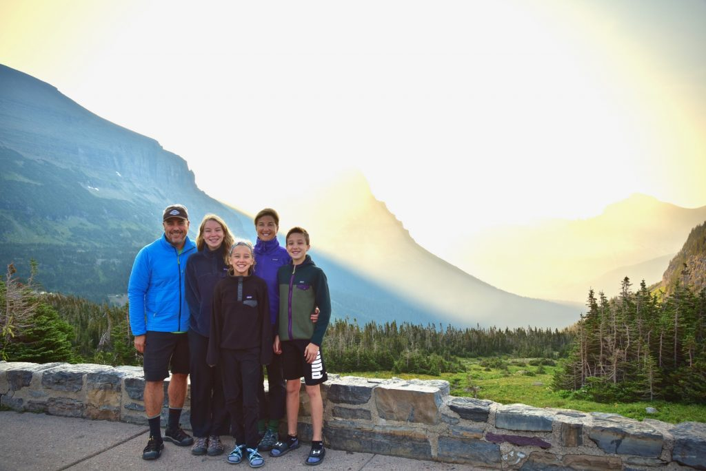
Logan Pass Visitor Center
If you want to get a parking spot for the Highline Trail, get up and going early!
Every Glacier National Park Ranger
The Logan Pass Visitor Center parking lot fills very early – every ranger we spoke with said that if we got there between 7:00-7:30 AM, we should be ok. We planned on playing it safe and to arrive at 7:00, which meant we would have to leave Many Glacier by 6:00 AM. Plan accordingly based on where you are staying/camping.

The kids were not being very excited about getting up at 5:30 but we were loaded up and on the road by 6:00 AM as planned. Interestingly, as we left Many Glacier Campground, we noticed the very long line of cars – at least 25 of them – waiting for the first come, first serve spots to be assigned by the campground host. This is pretty typical for Many Glacier in peak season.
Read more about our stay at Many Glacier Campground

Once we left the Many Glacier area, we were one of about 4 cars heading out, presumably to the same destination. As we re-entered the park at St. Mary and began heading west, our convoy grew in size and I figured everyone was heading to Logan Pass along with us. Surprisingly, a number of the cars pulled off around St. Mary Lake to photograph the sunrise as it lit up the peaks that line the Going to the Sun Road as you head west. I wish we would have had time to stop and take photos, it really was impressive.

In order to save time, we didn’t eat breakfast or make coffee at the campsite. I brought our MSR Windburner stove to make oatmeal and coffee/hot chocolate in the parking lot once we knew we had a spot. This turned out to work out well as the lot was already half-filled when we got there and completely filled by the time we were done having breakfast.

Getting to the lot early got us a spot and allowed us to depart on our hike before the majority of others, which meant fewer people on the trail. From what we were told, it can get quite crowded on near the trailhead after 9:00 AM.

Caution – Exposed Trail Ahead!

After the first 400 meters or so, you are greeted by the infamous exposed section of the trail – its about 6 feet wide and is roped on one side with a cliff dropping a hundred plus feet down on the other. This exposed section is only about a third of a mile in length but, for those with a fear of heights, it may feel much longer. Fortunately, it was less intimidating than expected and we made our way through this section quite easily; we took our time and there is the rope/chain to hang on to if you want. It might be a different story if it was crowded/jammed with traffic.


After the exposed section, the trail becomes more “traditional” in the sense that it is a well worn single track that hugs the slopes of the well-known Garden Wall. The trail doesn’t have any exceptionally steep or strenuous sections (unless you elect to do the Garden Wall spur – more on that later) but what it does have is plenty of incredible views.


Haystack Pass
About 3.5 miles into the hike, you will encounter Haystack Pass and Butte. The pass is a saddle that includes one long switchback that climbs up to the saddle and flattens out. It’s a natural rest point and provides excellent views of the entire area. Many people use this as their end point for the hike and start back towards Logan Pass, making for a shorter out-and-back hike. We did notice that trail traffic thinned out a bit after this point.


All Downhill From Here?
After Haystack Pass, the trail continues to climb for about another half mile before reaching its high point (if not doing the Garden Wall spur) at roughly 7390 feet. From there, it’s all downhill – unless you are going to do the Garden Wall Trail, which we strongly recommend if you are up to it!

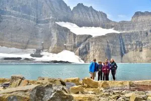
Family shot just after Haystack Pass. We stopped about 5 miles in for a Clif Bar break. The scenery was terrible. Getting closer to the Garden Wall Trail.


The Garden Wall Trail

After 6.7 miles, you will encounter a short trail spur that leads to a saddle that overlooks Grinnell Glacier, Salamander Glacier, and Upper Grinnell Lake. This is an optional out-and-back trail that looks much more ominous in person than it does on paper. Only .6 mile in length, it gains about 1000 feet in that short distance, making it pretty darn steep.
We’re not going to hike that – are we?
Makena
We had discussed doing this trail with the kids previously and decided that we would make a “game time decision” once we got there regarding whether we would do it or not. When the time came and we were presented with the view of this steep trail snaking upwards, there was definitely some hesitance from our youngest two kids. After some quick discussion and promises that we would take it slow and steady, we all agreed to give it a go.

To help encourage the kids, we told them that it was, “just like doing Brady’s Bluff twice”, which helped put this into context. Brady’s Bluff is a popular hike we frequently do in Perrot State Park back home in Wisconsin. If you do the short loop, it’s about 2 miles and has about 500 feet of vertical. If you do the longer loop, it’s about 900 feet of vertical over 3.4 miles.
The trail spur starts at 6,600 feet and is just over a half mile in length in which you climb almost 1000 feet.
The trail is definitely a burner and can be slick due to its grade and small loose gravel. Trekking poles really helped with stability in this section. The trail spur starts at 6,600 feet and is just over a half-mile in length in which you climb almost 1000 feet. You can go even higher if you want to follow some of the unmaintained trails that take you further along the continental divide to the SE. All that being said, if you take your time and don’t make it a race, it is so worth it…
Grinnell Overlook

Reaching the top of the Garden Wall Trail, you are gifted an awe-inspiring view of Grinnell Glacier, Salamander Glacier, and Upper Grinnell Lake far below. We were looking down with amazement on the endpoint of the Grinnell Glacier Trail, where we had just been a few days prior. It really puts things into perspective.

Then looking back to the south were more epic views that we hadn’t noticed on the way up. We took some time to rest and simply take in what we were seeing; it truly was amazing. There was a sense of accomplishment and satisfaction that is difficult to put into words…


Granite Park Chalet
About 7.7 miles from the Highline trailhead at Logan Pass is the Granite Park Chalet. Built in the early 1900s by the Great Northern Railroad, it is a national historic landmark and now serves as a resting spot at the confluence of a number of trails in the park. It does have a small store where you can purchase small snacks, dehydrated meals, and water. It also offers hostel-style bunks where some hikers elect to spend the evening (requires a reservation).

Ricky at Granite Park Chalet. Unfortunately, this is our only close up shot of the chalet itself. Looking back at Grinnell Overlook and the Garden Wall from Granite Park Chalet. At Granite Park Chalet.


Granite Park Trail
After resting and eating at the chalet, we connected to the Granite Park Trail, which leads directly to The Loop shuttle stop. This section of the trail is ALL downhill and is at a much steeper downhill grade than the rest of this hike – trekking poles were a savior to my knees and back.
Unfortunately, I didn’t take any photos on this section of the hike. Due to it being downhill, our pace was faster and we simply didn’t stop to take photos, which I regret. One thing to note is that this section of the trail has little to no shade; it is largely in a burn area from a recent fire and the afternoon sun can be very hot. Make sure you have plenty of water in this section! We noticed a number of hikers that underestimated this and were exhausted, especially at the end of the hike.
Once we arrived at The Loop parking lot and shuttle station, there was already a very long line waiting for the shuttle. We ended up waiting at least 45 minutes to an hour to catch a ride back to Logan Pass Visitor Center, where our car was parked. One option we heard others in line talking about that would eliminate any waiting for a shuttle is to park at The Loop parking lot in the morning, grab a shuttle to Logan Pass, hike, then arrive at your car.
Useful Links & Info
- Logan Pass Visitor Center Parking Status
- The Loop & Garden Wall Trail Info on AllTrails.com (note – the point-to-point route is reversed on this example).


Great pictures and a wonderful description of your family hike on the Highline TraiL & the Garden Wall. Thank you.